
Hélio do Prado
Presidente da Solum
OpAA73
Pedologia: o estudo dos solos
A demanda crescente por energias renováveis aumenta cada vez mais. Nesse contexto, a cana-de-açúcar é importante opção para suprir a necessidade de etanol e da bioenergia, com direto impacto na sustentabilidade.
Segundo a Conab, para a safra 2021/2022, a estimativa de produção é de quase 585 milhões de toneladas de cana-de-açúcar. De acordo com a NASA, o Brasil possui 400 milhões de hectares agricultáveis, dos quais 8 milhões são cultivados com cana-de-açúcar. Em 1950, foi iniciado o estudo pedológico – de solos –, no Brasil, ainda hoje somos apenas 60 pedologistas, completamente insuficientes para as demandas atual e a de um futuro próximo.
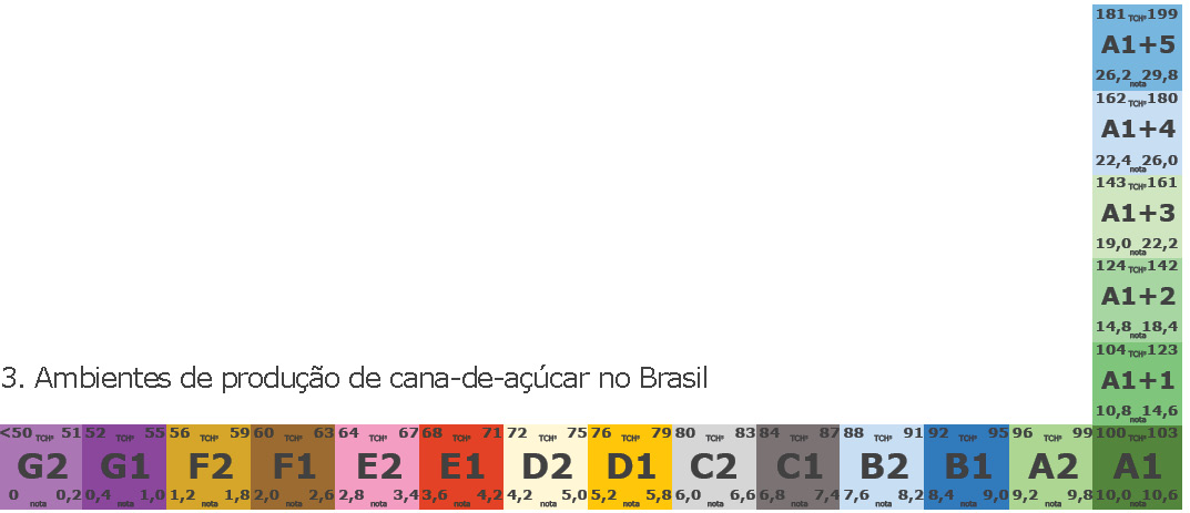
No Brasil, existem 13 tipos de solos no nível de classificação mais genérico e mais de 100 subtipos quando se consideram todos os detalhes pedológicos. Para se conhecer o potencial produtivo da cana-de-açúcar, é indispensável considerar o clima, o tipo de solo e o nível de manejo, o que representa ambientes de produção. Os solos mais comuns são os Latossolos e os Argissolos. Somente os Argissolos possuem grande diferença nos valores de argila entre a camada arável e abaixo dela, conferindo uma maior capacidade de armazenamento de água, que varia na profundidade onde ocorrem no perfil de solo.
Observa-se claramente o efeito dessa diferença na melhor brotação da planta no Argissolo e na pior brotação no Latossolo, sob o mesmo nível de manejo, conforme demonstra a Figura 1.
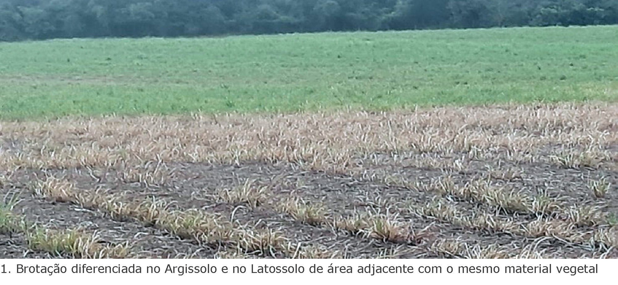
Na pedologia, diversas ferramentas são utilizadas para automatizar os processos de produção e contribuir com um tempo de resposta mais rápido nos resultados e nas tomadas de decisões. O sensoriamento remoto é uma delas e, através de imagens de satélite, vem trazendo eficiência para a pedologia e os ambientes de produção, realizados pelas equipes de campo. Nesse método, a análise do solo é feita por reflectância (forma de energia refletida do solo e obtida na forma de radiação eletromagnética), por sensores presentes em satélites, desde que o solo esteja descoberto.
Devido aos diferentes componentes de cada solo, podemos obter diferentes respostas de comprimento de ondas, levando a algumas correlações interessantes, na camada arável dos solos, como observado na Figura 2.
Os modelos de elevação dos solos permitem avaliar a topografia de uma área e fazer boas correlações com possíveis variações dos tipos de solos, auxiliando a equipe de campo na coleta de dados.
Vários trabalhos vêm abordando a importância de unir várias “camadas” de informações, como imagens de satélite e modelos de elevação, em séries temporais, e realizando machine learning (aprendizado de máquina) com o objetivo de obter uma classificação de solos mais rápida e precisa, sem a necessidade de ir à campo.
Resultados interessantes estão mostrando algumas correlações que já possuem grande utilidade para a pedologia e, consequentemente, para os ambientes de produção. Entretanto, ainda são necessários aprofundados estudos e mais publicações na área, para que nos permitam estabelecer metodologias com maior acurácia, principalmente considerando os solos existentes da camada arável, bem como o logo abaixo dela. Muitos solos possuem uma forte correlação com alguns modelos de topografia, mas isso não necessariamente permite identificar o solo que realmente é, tampouco mudanças na sua cor significam, necessariamente, mudança de solo.
O trabalho de classificação de solos no campo é sempre necessário, possibilitando elaborar mapas pedológicos fiéis das áreas, com escalas de publicação compatível com os níveis semidetalhado ou detalhado, alimentando bancos de dados que possam tornar realidade a inteligência artificial.
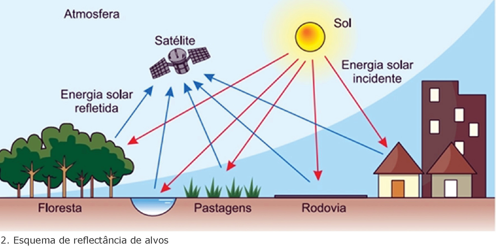
Na forma de régua, são apresentados os diferentes ambientes de produção de cana-de-açúcar, em que se indicam as respectivas produtividades médias de cinco cortes (TCH5), figura 3.